Understanding the California US District Court map is absolutely essential for anyone navigating the federal legal system within the Golden State. This vital resource delineates the precise geographical boundaries for the United States District Courts, impacting where lawsuits are filed, which local rules apply, and ultimately, how federal justice is administered. It is an indispensable tool for attorneys, litigants, and even the curious public seeking clarity on federal judicial reach across Californias diverse regions. The map illustrates the four distinct federal districts: the Northern, Eastern, Central, and Southern, each operating with its own courthouses and specific jurisdictional scope. For anyone needing to file a federal claim or defend against one, knowing the exact district relevant to their case is not merely a formality; it directly influences legal strategy, resource allocation, and procedural compliance. This detailed guide explores what the California US District Court map shows, why these divisions exist, where to find accurate information, and how a clear understanding empowers individuals to confidently engage with the federal judicial landscape. It demystifies the structure of federal courts, making the often-complex legal environment more accessible and manageable for all.
Ever wondered why California, a state so immense and diverse, requires a specific map just for its federal courts? What exactly is this California US District Court map, and why does understanding it matter for anyone involved in a federal legal matter? This essential navigational tool delineates the geographical boundaries for the United States District Courts within California, impacting who files where, what laws apply, and ultimately, how justice is administered. It defines the operational territories for the federal judiciary, ensuring cases are heard in the appropriate venue. For lawyers, plaintiffs, defendants, and even curious citizens, knowing the specifics of this map is not merely academic; it is fundamentally practical. When do these district boundaries come into play? Primarily when initiating or responding to a federal lawsuit, as the chosen district determines where proceedings commence and which specific court rules apply. Where are these courts located, and why are there distinct divisions rather than a single, monolithic federal court for the entire state? These divisions ensure efficient management of an overwhelming caseload, allowing for localized expertise and accessibility. How does one effectively use this map to navigate the often-complex federal judicial system? By carefully identifying the relevant district based on the residence of parties involved or the location where the legal action occurred, individuals gain a crucial first step towards understanding their path through federal litigation, making the federal system feel much more approachable.
Understanding the California US District Court Map: What You Need to Know
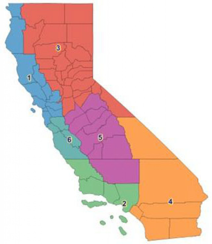
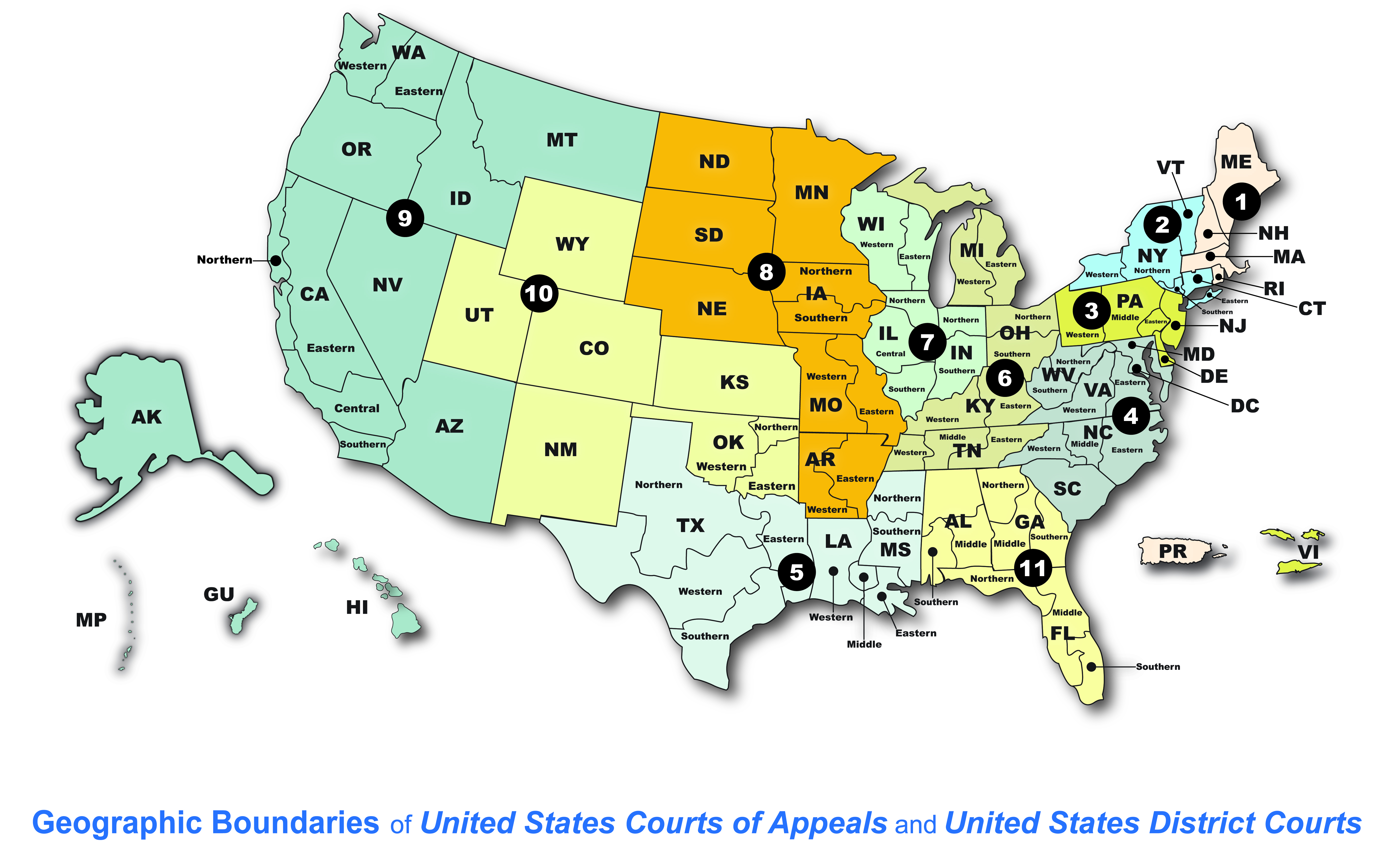
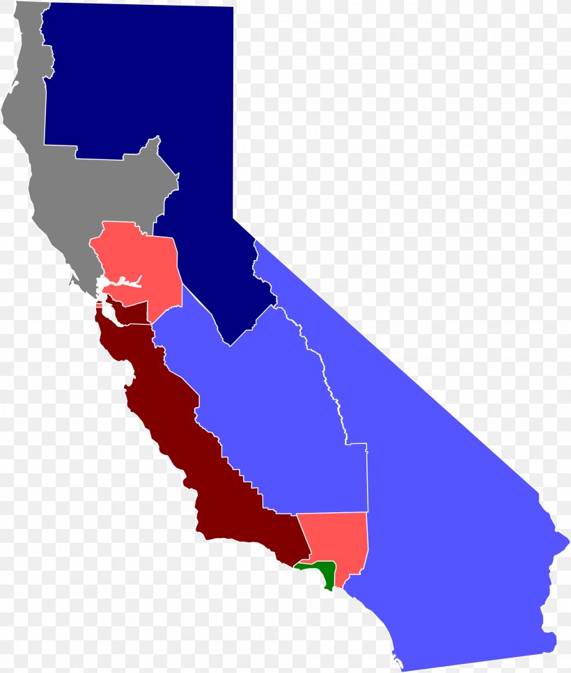
What precisely does the California US District Court map show us, and why is this division so critical for the smooth functioning of federal law across the state? At its core, this map visually outlines the four distinct federal judicial districts that carve up California: the Northern, Eastern, Central, and Southern Districts. Each district operates independently with its own courthouses, judges, and administrative staff, all under the umbrella of the United States federal court system. This intricate partitioning serves a vital purpose: it ensures that the immense volume of federal cases arising within California’s vast geographical and demographic landscape is managed effectively and fairly. Why would the federal government go to such lengths to divide a single state into multiple judicial zones? The answer lies in the principle of venue and judicial efficiency. Without these clear boundaries, determining the proper court for a federal claim—be it intellectual property disputes, civil rights violations, or federal criminal charges—would be a chaotic and inconsistent endeavor. How do these districts actually impact an ordinary person or business? If you are involved in a federal legal dispute, the specific district where your case falls dictates where you file your legal documents, where court hearings take place, and which set of local rules, though largely consistent with federal rules, might have minor unique interpretations or procedural nuances. The map provides an unambiguous guide, preventing forum shopping and ensuring legal proceedings remain orderly and accessible to those directly affected within a particular region.
The Four Pillars of Federal Justice: Exploring Californias Districts on the California US District Court Map
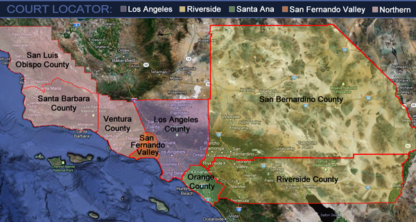
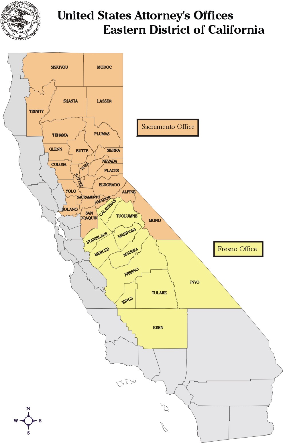
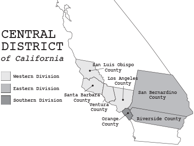
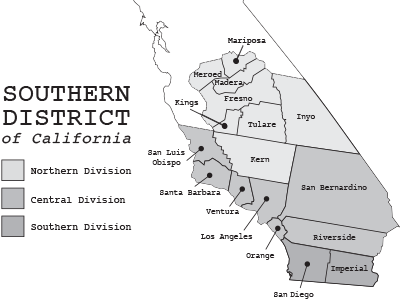
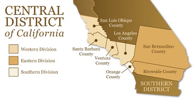
What distinguishes the Northern, Eastern, Central, and Southern Districts of California, and how does the California US District Court map help us visualize these divisions? Each of these four districts possesses a unique character, geographical scope, and often, a distinct caseload profile reflecting the economic and social fabric of its region. The Northern District of California, headquartered in San Francisco, covers the dynamic Bay Area and extends northward, frequently handling complex tech-related litigation due to the significant presence of Silicon Valley. Its jurisdiction includes some of the nation’s most innovative companies and a densely populated urban corridor. The Eastern District, with its primary seat in Sacramento, spans a vast agricultural and inland region, stretching from the Oregon border down to Fresno. It deals with diverse issues, including water rights, environmental law, and rural community concerns. Then there is the Central District of California, arguably the largest federal district by population in the entire United States, centered in Los Angeles. This district encompasses the sprawling urban landscape of Southern California, including Los Angeles, Orange, Riverside, San Bernardino, Ventura, and Santa Barbara counties, handling an immense volume of civil and criminal cases, from entertainment law to complex commercial disputes. Finally, the Southern District of California, based in San Diego, covers the southern border region and coastal areas, frequently addressing immigration, maritime law, and international trade matters. Why were these specific geographical lines drawn? They evolved over time to accommodate population growth, economic activity, and the need to distribute judicial resources equitably across a state with diverse legal demands. Understanding these distinctions through the California US District Court map empowers individuals to grasp the precise federal legal arena relevant to their specific situation, clarifying where they stand in the federal judicial landscape.
| District | Headquarters | Key Counties/Areas Covered |
|---|---|---|
| Northern District of California | San Francisco | Alameda, Contra Costa, Del Norte, Humboldt, Lake, Marin, Mendocino, Monterey, Napa, San Benito, San Francisco, San Mateo, Santa Clara, Santa Cruz, Sonoma |
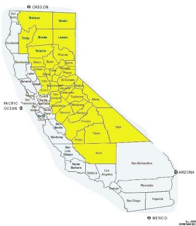
| Eastern District of California | Sacramento, Fresno | Alpine, Amador, Butte, Calaveras, Colusa, El Dorado, Glenn, Inyo, Kern, Lassen, Madera, Mariposa, Merced, Modoc, Mono, Nevada, Placer, Plumas, Sacramento, San Joaquin, Shasta, Sierra, Siskiyou, Solano, Stanislaus, Sutter, Tehama, Trinity, Tulare, Tuolumne, Yolo, Yuba |
| Central District of California | Los Angeles, Santa Ana, Riverside | Los Angeles, Orange, Riverside, San Bernardino, San Luis Obispo, Santa Barbara, Ventura |
| Southern District of California | San Diego | Imperial, San Diego |
Navigating Jurisdiction: Why the California US District Court Map is Crucial for Understanding Legal Reach
Why does the California US District Court map hold such critical importance when determining the appropriate forum for a federal lawsuit, and what precisely is at stake when jurisdiction and venue are incorrectly identified? This map serves as the foundational guide for understanding where a federal case can and should be filed, a concept known as venue. Federal courts possess limited jurisdiction, meaning they can only hear specific types of cases outlined by federal law and the U.S. Constitution. Once it is established that a case falls within federal jurisdiction—for example, it involves a federal question or diversity of citizenship—the next crucial step is pinpointing the correct district within California. How does this work in practice? Generally, a federal lawsuit should be brought in a district where a defendant resides, where a substantial part of the events giving rise to the claim occurred, or where property subject to the action is located. The precise lines on the California US District Court map directly dictate these geographical considerations. What happens if you file in the wrong district? An incorrect filing can lead to significant delays, motions to transfer the case, or even outright dismissal, costing parties valuable time and resources. Lawyers diligently consult this map to ensure their clients cases are properly initiated, safeguarding against procedural missteps. The map is not just a drawing; it is a practical instrument that enforces the orderly administration of justice, ensuring each federal district court handles cases appropriately tied to its specific region, preventing overburdening of certain courts and maintaining efficiency across the federal judicial system.
Practical Implications: How the California US District Court Map Shapes Your Case
How does the detailed information provided by the California US District Court map translate into tangible, real-world implications for individuals and businesses engaged in federal litigation? Understanding which district applies to your case profoundly affects everything from the selection of legal counsel to the specific procedural nuances you will encounter. When you know your district, you gain immediate insight into the pool of local attorneys who practice regularly in that particular court, ensuring they are familiar with the specific judges, court staff, and local rules that might influence your cases trajectory. What are some other practical considerations? The location of the courthouse itself, as dictated by the California US District Court map, impacts travel logistics for parties, witnesses, and legal teams, potentially influencing costs and convenience. Furthermore, each district, while adhering to federal rules, often develops its own local rules that can govern everything from filing deadlines to the format of legal documents, and even specific procedures for certain types of hearings. Why is this local variation important? It means a legal strategy that works effectively in the Northern District might require slight adjustments when practiced in the Central District. Knowing your district in advance allows for proactive planning, reducing surprises and improving the efficiency of the legal process. The map thus acts as a vital blueprint, guiding legal professionals and litigants through the complex landscape of federal court administration and ensuring that cases proceed smoothly and predictably within their designated judicial home.
Accessing Justice: Where to Find Resources on the California US District Court Map
Where can one find reliable and up-to-date information regarding the California US District Court map, and how can individuals ensure they are consulting the most accurate resources? Fortunately, official and readily accessible sources exist to help anyone navigate these federal judicial divisions. The primary and most authoritative resource is typically the official website for the United States Courts (uscourts.gov), which provides comprehensive information on all federal courts, including detailed maps and boundary descriptions for each district. Why is it important to rely on official sources? These sites offer the most current data, reflecting any boundary changes or updates that might occur. Additionally, each of Californias four federal district courts—the Northern, Eastern, Central, and Southern Districts—maintains its own dedicated website. These individual sites not only feature their specific portions of the California US District Court map but also provide invaluable local rules, contact information for clerks offices, and details on court procedures relevant to their unique jurisdiction. How can one effectively utilize these resources? By visiting these websites, individuals can visually confirm the boundaries, verify the correct courthouse location for their specific county, and access a wealth of information that supports their engagement with the federal justice system. These resources empower everyone, from seasoned legal professionals to members of the public, to confidently understand and interact with the federal courts, ensuring informed participation and access to justice within the precise geographical confines of the California US District Court map.
What is the key takeaway regarding the California US District Court map? The California US District Court map is an essential tool delineating the four federal judicial districts in California—Northern, Eastern, Central, and Southern—crucial for determining proper jurisdiction and venue for federal cases, ensuring efficient justice administration across the state.
Keywords: california us district court map, federal court districts california, northern district california, eastern district california, central district california, southern district california, california federal court jurisdiction, california judicial map, federal court divisions california, us district court california explained, federal litigation california, california court boundaries, federal justice system california
The California US District Court map divides the state into four distinct federal judicial districts: Northern, Eastern, Central, and Southern. This map is crucial for determining jurisdiction and venue for federal lawsuits, ensuring cases are filed in the correct court. Each district operates independently with its own judges and local rules, impacting legal strategy and case proceedings. Understanding these divisions is vital for legal professionals and the public to navigate the federal justice system effectively. Official government websites provide the most accurate and up-to-date information on the California US District Court map and its boundaries.
California State Assembly District Map Screen Shot 2021 11 11 At 4.15.30 PM CA Supreme Court Denies Republicans Request To Intervene In Newsom S 17550795 081525 Kfsn Map Draft Supreme Court Cases October Term 2025 2026 Ballotpedia 1000px US Court Of Appeals And District Court Map
Eumi Lee Ballotpedia 600px Northern District Of California The 1960s Central District Of California United States District Court Central District Map Maps Judicial Branch Of California Screenshot 2025 02 05 31316 Pm 0 California District Court Map Atlas Of California Map United States District Court Png Favpng
Six California House Races That Could Determine Control Of Congress 75Historical Decades Central District Of California United States Southern District Map Court Locator Central District Of California United States California District Court Map CDCA Map Lg
Bankruptcy Court Eastern District Of California Fresno Map New3 California District Court Map Png Clipart California United States District Court Federal Judiciary Of The United States Federal Government Of The United States Map Angle Plan New York District Court Map Full Map Of The United States 11 Districts California Districts Map Board Of Trustees Districts Inside California State Assembly District Map
Map Shows Democratic Plan For New California Districts Newsweek Map Us California District Court At Vaughn Josephs Blog District Network Map Explore Newsom S Proposed Map How Five New Seats Could Untitled 1 18 08 2025 23 48 28 New Draft Of Map Shows Proposed Lines In Ff6dcc51 3374 4aab B1fc 1920x1080
California S 26th District Election 2024 March 5 Top 2023 01 03 Ca District 026 Court And County Directory CCAP District Map 1 Eastern District Of California Eastern District Of California Cal Map EDCA Sac Fresno Florida State District Courts Map U S District Courts N
District Map California Screen Shot 2021 02 15 At 2.15.26 PM Map Of California Districts QkFMwrCentral District Of California United States Territory Map Sidebar District Map California Screen Shot 2021 02 15 At 2.15.36 PM
California S 26th District Ballotpedia 550px CA26 California District Court Map California Interactive Map Compares Current And Proposed SJM L 0822 90